Welcome to the blog of Fred and Julaine as we chronicle our adventures traveling on Boreas, our Carver 405.


Wednesday, August 31, 2011

Day 54 - Chicago to Joliet - August 29, 2011

We left our slip at DuSable Harbor this morning at 8:00am.  A few minutes later we were approaching our very first lock, the Chicago Harbor Lock, which separates Lake Michigan and the Chicago Sanitary and Ship Canal (what most people think of as the Chicago River).  The best thing about this lock is that it doesn’t have a very large elevation change, just a bit less than 2 feet.  They have lines hanging down the lock walls for you to use, so you grab a line and hang on for the ride down.  After exiting the lock, you are in the river and headed through downtown Chicago.

Three-and-a-half miles down the river is an Amtrak railroad bridge that has to open for us to pass – it has a clearance when closed of just 10 feet.  This bridge won’t open during rush hour, but after that will open for pleasures boats as long as a train isn’t coming.  We called to the bridge operator and after waiting for two trains we passed through.  The scenery changes quite dramatically after this bridge, going from skyscrapers to industry to trees and barge terminals.

About 24 miles after leaving the Chicago Harbor Lock, the Chicago Sanitary Canal and the Calumet Sag Channel (Cal-Sag) join.  Boats that can’t get under the 17’ air draft requirement take the Cal-Sag.  The next five or so miles is a large towboat and barge parking area.  It is very difficult to pass in this area; barges are tied to the shore edges leaving just enough room for an oncoming barge to pass.  We encountered a towboat pushing 9 barges in this area and spent about 30 minutes hanging out very close to the canal wall while he passed.  Fred did a great job handling the boat while the barges went by.

Finally we arrived at our first really big lock, the Lockport Lock.  This lock lowers the boat over 40 feet.  I was quite nervous about how everything would work, but Tyrone the lockmaster was extremely helpful.  All six of the boats in the lock with us were pleasure boats.  We were assigned the farthest back floating bollard on the starboard side of the lock and they asked Brandy IV to raft off of us.  So, we put fenders out on both sides of the boat and Tyrone helped me get a line around the bollard – two wraps and then cleated back on the mid-cleat of the boat.  The floating bollard was great; I basically stood near it and monitored our progress down.  The boat pivoted on the mid-cleat and the bumpers kept us off the lock wall.  Forty feet down is a lot, but it only took about 15 minutes.  It is hard for me to imagine what some of the locks on the Tennessee River will be like with changes in elevation of over 80 feet.

We decided to save the next lock for tomorrow and are tied up at a park wall in Joliet.  This is a free dock sponsored by the city.  The wall is a bit rough, but there are 30amp outlets mounted into the concrete pillars of the seawall so we were able to cool off and cook dinner without running the generator.

            Miles: 36.7      Bridges: 65      Locks: 2

Boreas with the radar down and the cockpit canvas removed so
that we can easily get under the bridges in Chicago
Boreas all set to begin the trip down the Chicago River
Boreas just before we depart from DuSable Harbor in Chicago
the entrance to the Chicago Harbor Lock - our first lock!
a boat leaving the Chicago Harbor Lock  just before we enter
we are through the Chicago Harbor Lock and heading for the
first bridge at Lake Shore Drive
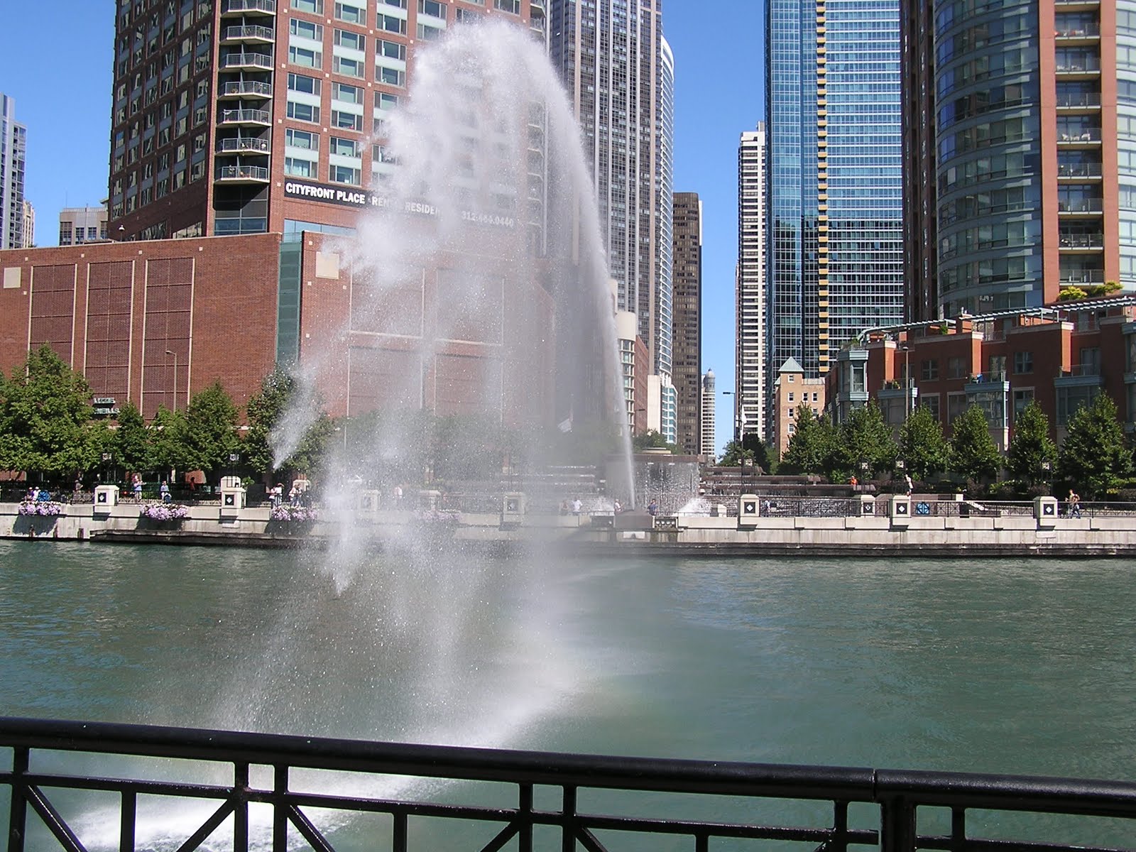
we have passed under the first bridge and are looking
down the river toward Trump Tower Chicago
we traveled under 65 bridges today, most of them in the
first few miles through downtown Chicago
bridges in Chicago
65 bridges is a lot - here are a few more of them
just in case you thought we were kidding about
all the bridges, here are a few more
just 4 miles down the river is the Amtrak Rail Road Lift Bridge
in its down position it is just 10 feet above the water, so it has
to open for us to go under (notice the train on the bridge - we had
to wait for 2 trains to go by before they would open for us) 
the Amtrak Rail Road Bridge beginning to open
once you leave the city of Chicago, this is what the river begins
to look like
aeration falls at the water treatment plant where the Chicago Sanitary
and Ship Canal meets the Cal-Sag Channel
barges line the banks of the river waiting to be picked up by a tow and moved
these were some of the tows waiting for that very large barge to pass
in the Lockport Lock tied up and waiting to go down
in the Lockport Lock, we are all the way down and the gates
are starting to open
in the Lockport Lock, the gates are fully open and we are
heading out

Day 53 - DuSable Harbor, Chicago - August 28, 2011

We spent a relaxing day in Chicago today.  We walked to a very nice grocery store and stocked up on a few last minute items.  The walk to the grocery store took us on a path along the Chicago River and we had a chance to take a few pictures from the shore (we’ll get the “from the boat” pictures tomorrow).

We also had a chance to meet and talk to a number of other Loopers who were also staying at DuSable Harbor.  We will be heading out tomorrow with John and Rita from Toronto who are aboard Brandy IV.  Their “air draft” is just a bit more than ours and John wants to watch us go through the bridges ahead of him. 

            Miles: 0           Bridges: 0        Locks: 0
water cannon at the Melas Fountain shooting an
arc of water over the Chicago River

from the Columbus Street bridge, looking out toward
Lake Michigan and the Lake Shore Drive bridge
the arc of the water cannon

from the Columbus Street bridge, looking down the river -
Trump Tower Chicago is the building with the reflective glass
windows in the center of the picture

Saturday, August 27, 2011

Day 52 - DuSable Harbor, Chicago - August 27, 2011

We got up early today and headed to Shedd Aquarium.  We walked along next to Monroe Harbor to get from the boat to the aquarium.  The lakeshore in Chicago is amazing.  There are pedestrian/bike paths all along the water’s edge between Lake Shore Drive and the water.  They are used all day long by runners, walkers, bikers, people on roller blades and even tourists seeing Chicago on a  Segway (a 2-2.5 hour tour is around $50 per person).

We need to get our “air draft” (the distance from the water to the top part of the boat) under 17 feet to get under all the bridges in Chicago.  This means we need to remove the radar, the anchor light and the canvas over the helm station.  We got the radar and anchor light taken care of today and will do the canvas right before we depart.  And speaking of departure, we originally planned to head out Sunday morning (August 28, 2011), but have decided to move that back to Monday.  The wind is still predicted to be blowing quite hard all day Sunday, diminishing later in the day.  We think the advantages of traveling on Sunday (less barge traffic and no issues with the opening of the Amtrak bridge) are outweighed by the disadvantages of trying to manage our first lock when the wind is blowing over 25 knots.

We got to watch fireworks from the boat tonight.  Chicago’s Navy Pier hosts fireworks on Wednesday and Saturday nights during the summer.  Other than fireworks after a Loons game at Dow Diamond, this is the best place for fireworks viewing

            Miles: 0           Bridges: 0        Locks: 0


Day 51 - New Buffalo to Chicago - August 26, 2011

The winds diminished over night and the wave forecast was for waves at 1 foot or less.  The course to Chicago is almost straight west from New Buffalo.  We left the New Buffalo channel and were immediately rocked by left over swell from the high winds from the previous days.  And we are talking about BIG swells – some of the left over waves were in the 3+ foot range.  We headed a bit north of our course hoping to minimize the rocking until the swell had a chance to roll itself out.  Not long after we left the waves did abate some and we were able to turn back to our correct course.

One of the most amazing things we discovered on this crossing was that we could actually see the largest (and darkest colored) buildings in the Chicago skyline from over 25 miles away.  We weren’t sure what we were seeing when we first started seeing shapes on the horizon, but we now know we were seeing the Willis Tower (formerly the Sears Tower) and the John Hancock Building.  We started taking pictures at 20 miles away and it is amazing what you can see.

We originally had reservations to stay at Burnham Harbor while we were in Chicago, but because of predicted wind direction and velocity, we called DuSable Harbor to see if they had any slips open.  The wind prediction for Saturday and Sunday is for quite strong winds (20 to 30 knots) and DuSable Harbor is inside the outer break wall which will make getting to the lock at the mouth of the Illinois River much easier no matter what the wind and waves are doing.  DuSable had an opening that would fit Boreas, so we cancelled our reservation at Burnham Harbor and we’re safely tied up in a slip at DuSable Harbor.

We had dinner tonight with our friends John and Alice at a wonderful Italian restaurant in their neighborhood.  John picked us up at the harbor and we were able to walk from their house in Old Town Chicago to the restaurant.  It was a great evening and we enjoyed talking about our “Great Loop” route and the things we are hoping to see and do while we’re looping.

            Miles: 43.8      Bridges: 0        Locks: 0
the Chicago Skyline from 15 miles away

the Chicago Skyline from 10 miles away

the Chicago Skyline (the John Hancock Building is the
dark building in the back with the two white antenna towers)

Chicago Skyline (Willis Tower is the dark
building in the back of the photo) 

the Chicago Skyline (south end of the skyline)
the Chicago Skyline (with Navy Pier on the far right)
Chicago Harbor Lighthouse

the fountain at Grant Park
(this is the view as you enter Monroe Harbor on the way to
DuSable Harbor)

Boreas in her slip at DuSable Harbor
(radar and anchor light still on)

Thursday, August 25, 2011

Days 49 & 50 - in New Buffalo - August 24-25, 2011

Due to wave conditions on Lake Michigan we spent two more nights in New Buffalo.  The waves on Lake Michigan have been in the 3 to 6 foot range these last two days.  We often talk about the fact that different types of boats (power versus sail) are better in different conditions.  Perfect sailing conditions are not necessarily perfect conditions for being in a power boat and these past two days have been good sailing weather, not good power boating weather.  But don’t take that to mean we are unhappy with Boreas because that is very far from the truth – we just aren’t always used to the weather conditions we can and can’t travel in.

New Buffalo boasts the largest number of slips on the western coastline of Lake Michigan – over 1,100 slips!  We have taken dinghy rides the last two evenings to check out all the slips and they are right, there are a lot of them here.  Although this wouldn’t be our first choice for where to keep a boat for the summer, it is very convenient for people living in the Chicago area as well as those in northern Indiana and southern Michigan. 

            Miles: 0           Bridges: 0        Locks: 0
some of the many slips in New Buffalo

...and more slips

...and more slips

...and more slips

...and still more slips

...and more slips

...and more slips

...and a few more slips

...and still more slips

water cascading over the breakwall at the entrance to the
New Buffalo harbor

Wednesday, August 24, 2011

Day 48 - South Haven to New Buffalo - August 23, 2011

We were not sure we would be able to travel today as the weather forecast was for thunderstorms and high wind and waves.  We decided to get up early and do one last weather check and make our decision at that point.  The morning forecast for south of South Haven was milder than it had been the night before, so we started the engines and got moving before the sun was actually over the horizon.  We are anxious to get to Chicago and the three to five day weather forecasts don’t look good for travel.  If we are in New Buffalo we are just under 40 miles from our reserved dock at Burnham Harbor in Chicago.

Along the way to New Buffalo we planned a stop in St. Joseph for fuel.  As we have been making our calls ahead for diesel prices, we found that Pier 33 in St. Joseph was much cheaper than anyone else in the area.  The fuel price was good, but they were further up the river than we had originally thought and the water depth (or lack thereof) made us a bit uncomfortable.  We traveled quite a distance with the depth gauge reading only 4 to 5 feet.  The detour to St. Joseph took just over an hour, but all three fuel tanks are now full.

            Miles: 48.1      Bridges: 6        Locks: 0

Day 47 - Lake Macatawa to South Haven - August 22, 2011

We travelled 25.4 miles south today to South Haven and got a dock at South Haven Municipal Marina No. 2.  There are actually three different locations along the river that are all South Haven Municipal Marinas.  We stayed at the one on the south side of the river that is for transient boaters only (no seasonal slips are available).  If it is blowing hard out of the west, this location can get a bit uncomfortable as the waves roll down the channel and rock the boats; fortunately we didn’t have any issues.  Marina No. 2 is on the side of the river where the main shopping in South Haven is located so it is convenient if you want to check out the restaurants and shops.

We took a dinghy ride up the river and checked out the many places to keep your boat in South Haven.  There are more options than you can imagine with marinas, yacht clubs, condo docks and private docks for all types and sizes of boats.  You can definitely tell the difference between cruising “up north” in Michigan and cruising in southern Michigan.  The towns “up north” seem quiet and peaceful compared to what you find once you are south of Muskegon.

We have been following the Loop blog for a couple we met in Alabama last fall.  One of the things they keep track of for each day is miles, bridges and locks. Fred likes this tally, so we will begin putting this information at the end of each day’s blog.

            Miles: 25.4      Bridges: 0        Locks: 0
South Haven channel as we approach in Boreas

the view out the South Haven channel from the dinghy

the Tall Ship "Friends Good Will" that sails out of
South Haven

the Tall Ship "Friends Good Will"

securing a sail near the top of the mast (you can
see these two working in both of the other pictures as well)