Due to the weather outlook for showers and thundershowers today and tonight we decided to stay one more night at Green Turtle Bay. So we caught up on the laundry and got a few other boat tasks done. The Commonwealth Yacht Club is located at Green Turtle Bay and as a transient boater we are allowed to eat at the club, so that’s what we did for dinner. As we walked to dinner, we still had yet to have any rain, but the radar said it was coming so we closed up the boat and took an umbrella with us. And boy did it rain and thunder and lightning and blow. It started slow but once it got going it was an amazing light show with the rain coming down in sheets. After dinner was done, we stayed in the club for awhile and waited for the worst of it to end. We were sitting next to a couple who had just completed their Loop, so we had a chance to talk about where we are headed next and get their take on some of the good spots to stop.
Miles: 0 Bridges: 0 Locks: 0
Friday, September 16, 2011

Tuesday, September 13, 2011
Day 68 and 69 – Green Turtle Bay on Lake Barkley - September 12-13, 2011
I am so impressed. It isn’t often that you find the name of a place fits with the features of that place – how often are there actually maple trees on Maple Street? But not here – at Green Turtle Bay there are actually turtles. The turtles are relatively tame and don’t seem to have any trouble sharing their bay with us boaters.
Miles: 0 Bridges: 0 Locks: 0
Miles: 0 Bridges: 0 Locks: 0
 |
| a turtle at Green Turtle Bay |
 |
| a turtle sunning himself at Green Turtle Bay |
 |
| Is there any better life than being a turtle at Green Turtle Bay? |
 |
| another turtle enjoying Green Turtle Bay |
 |
| Not to be outdone by the turtles, a Great Blue Heron enjoys Green Turtle Bay. |
Day 67 – Cumberland Towhead Island to Green Turtle Bay on Lake Barkley - September 11, 2011
We started up the Cumberland River today toward the Barkley Lock and Dam, our first lock up – on all the other locks we have done so far we have started on the higher portion of the river and locked down to the lower portion. Today’s lock is also the largest change in elevation – we will be locking up over 57 feet (previous record was 34 feet).
The part of the Cumberland River that we traveled today is quite narrow and has very little barge traffic. In fact we didn’t encounter any barges today at all.
The locking through went very well, although I must say that it is intimidating to enter a lock where the top of the gate at the other end is over 57 feet above you. It is amazing how small you feel inside the lock. The best part however was exiting the lock and seeing Lake Barkley – what a beautiful lake! Green Turtle Bay Marina where we have reservations for the next few nights is just a mile or so from the lock. We are looking forward to a few days of rest and relaxation here before we move on.
Miles: 33.7 Bridges: 4 Locks: 1
 |
| starting up the Cumberland River |
 |
| the Cumberland River |
 |
| Bavarian Cream and Tropical Breeze following us up the Cumberland River |
 |
| limestone along the Cumberland River |
 |
| these rocks actually look like steps that someone placed here - it is amazing how nature does things! |
 |
| the lock gates on Barkley Lock closing behind us |
 |
| looking towared the front gates of Barkley Lock before we begin to go up |
 |
| the front gates of Barkley Lock opening up to Barkley Lake |
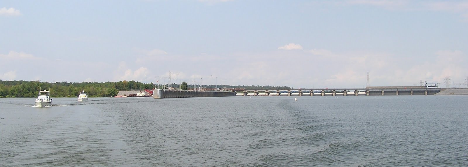 |
| looking back at Barkley Lock and Dam |
 |
| Barkley Lake |
Day 66 – Little Diversion Channel to Cumberland Towhead Island (upriver from Paducah, KY) - September 10, 2011
Today was our second very long day in a row at 106.8 miles – the first 48 were going with the current on the Mississippi and the remainder going against the current on the Ohio. We got to “see” three locks on the Ohio River today. I say “see” because the first lock we encountered is the Olmsted lock which is currently under construction. So we got to look at it as we motored by. Construction is expected to be complete sometime in 2013. When the Olmsted Lock and Dam is complete it will take place of the other two locks we encountered today, Lock and Dam 53 and Lock and Dam 52. I say encountered because we got to go right past both of these locks and did not have to lock through. Both of these dams are wicket dams. In times of high water, which the Ohio is experiencing right now, the wickets on the dam can be lowered and instead of locking through, you go right over the dam. Yes, I said right over the dam. However, without the signs and the lockmaster building telling you that you are passing a lock and dam (and a bit of turbulence), you would never even know the dam was there.
We have a new record for number of barges being pushed by a tow – the Carol McManus is the new leader at 34 barges. She was pushing 7 wide and 5 deep, but missing one barge in the front corner for a total of 34 barges – amazing.
We had a beautiful anchorage at Cumberland Towhead Island with three other boats that we travelled with today. We are all glad to be finished with the Mississippi and Ohio Rivers and into the Cumberland and Tennessee Rivers.
Miles: 106.8 Bridges: 8 Locks: 2 (wickets down, passed over dams)
We have a new record for number of barges being pushed by a tow – the Carol McManus is the new leader at 34 barges. She was pushing 7 wide and 5 deep, but missing one barge in the front corner for a total of 34 barges – amazing.
We had a beautiful anchorage at Cumberland Towhead Island with three other boats that we travelled with today. We are all glad to be finished with the Mississippi and Ohio Rivers and into the Cumberland and Tennessee Rivers.
Miles: 106.8 Bridges: 8 Locks: 2 (wickets down, passed over dams)
 |
| looking down the Lower Mississippi River just before we turn onto the Ohio River |
 |
| our first look up the Ohio River |
 |
| The Olmsted Lock and Dam construction site. The dark structures you see are part of the dam. They are assembled on land and then moved with the crane you see in this picture (the light gray structure with the red wheel on top) |
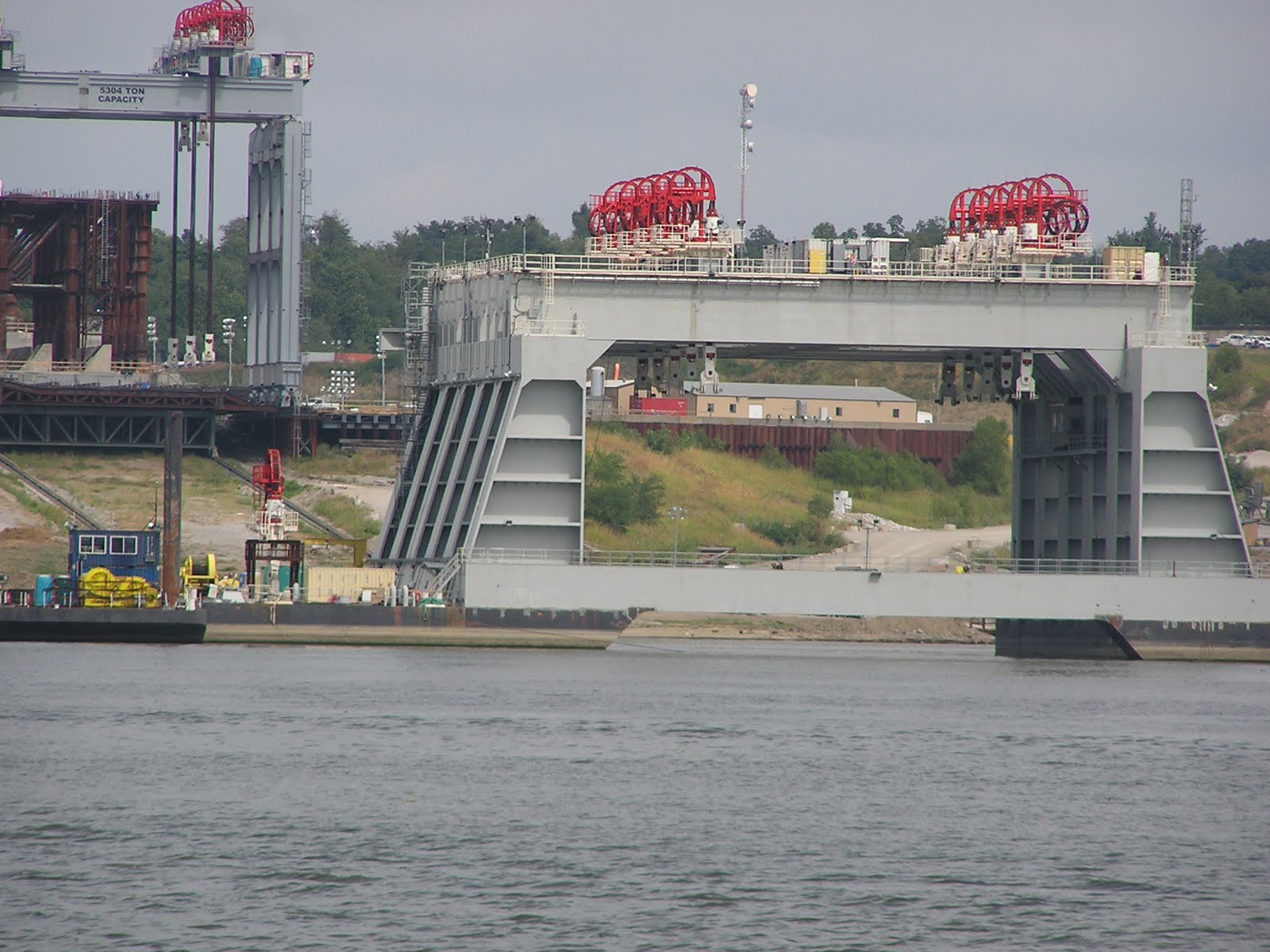 |
| The first crane (from the above picture and in the left corner of this picture) moves the dam parts into position for this second crane. This second crane is on barges and moves the dam piece into position in the river. The red wheels on top operate the mechanism that actually lifts the dam piece and hold it in place. |
 |
| In the center of this picture you can see one of the dam pieces being installed by the two large cranes. |
 |
| this is the new lock structure |
 |
| This is Lock and Dam 53. All you can see of the lock is two round cement bollards - everything else is underwater. |
 |
| A picture of the Dam 53 - you can see where the dam is by where the water changes from calm to turbulent. |
 |
| Our new biggest tow and barges - the Carol McManus with 34 barges! |
 |
| This is Lock and Dam 52. Slightly more of the lock structure is visible than at Lock and Dam 53. |
 |
| The sign says it all. |
 |
| turbulent water as we pass over Dam 53 |
 |
| the sunsets we see when we are at anchor are just amazing |
Day 65 – Hoppie’s Marina to Little Diversion Channel (near Cape Girardeau, MO) - September 9, 2011
Because you get to add the speed of the current to the speed of the boat, you really fly down the Mississippi without much work. We traveled 110 miles in 8 hours and 50 minutes (from lines off the dock to anchor down). We passed many tows and barges today. The tow captains are very friendly and seem to have no issues about talking with pleasure boaters about the safest way to make your pass.
Today we passed the tow Hank Tulodzieski, with the largest number of barges we have seen so far. He was pushing 30 coal barges – six barges wide by 5 barges deep. We got a brochure from the US Army Corps of Engineers that compares barges with other methods of moving goods. The 30 barges Hank T. was moving equals 450 jumbo train hoppers (or four and a half 100 unit trains) or 1740 semi trucks. With numbers like that it is no wonder moving goods by barge is such a good deal.
We passed by the Trail of Tears State Park north of Cape Girardeau, Missouri today. This state park is along the northern route of “The Trail of Tears”. If you are not familiar with “The Trail of Tears” it is the route the people of the Cherokee Nation traveled when they were forcibly removed from their homes in Georgia and relocated to reservations in Oklahoma. This is one of the saddest episodes in US history. The Cherokee people were taken from their land, herded into makeshift forts with minimal facilities and minimal food, and then forced to march a thousand miles. The human losses were extremely high. The route they traversed and the journey itself became known as “The Trail of Tears” or, as a direct translation from Cherokee, “The Trail Where They Cried”.
Miles: 110 Bridges: 2 Locks: 0
Today we passed the tow Hank Tulodzieski, with the largest number of barges we have seen so far. He was pushing 30 coal barges – six barges wide by 5 barges deep. We got a brochure from the US Army Corps of Engineers that compares barges with other methods of moving goods. The 30 barges Hank T. was moving equals 450 jumbo train hoppers (or four and a half 100 unit trains) or 1740 semi trucks. With numbers like that it is no wonder moving goods by barge is such a good deal.
We passed by the Trail of Tears State Park north of Cape Girardeau, Missouri today. This state park is along the northern route of “The Trail of Tears”. If you are not familiar with “The Trail of Tears” it is the route the people of the Cherokee Nation traveled when they were forcibly removed from their homes in Georgia and relocated to reservations in Oklahoma. This is one of the saddest episodes in US history. The Cherokee people were taken from their land, herded into makeshift forts with minimal facilities and minimal food, and then forced to march a thousand miles. The human losses were extremely high. The route they traversed and the journey itself became known as “The Trail of Tears” or, as a direct translation from Cherokee, “The Trail Where They Cried”.
Miles: 110 Bridges: 2 Locks: 0
 |
| beautiful cliffs along the Mississippi River |
 |
| Tower Rock - a very round island along the shore of the Mississippi River |
 |
| some of the limestone cliffs in "The Trail of Tears" state park |
 |
| the tow Hank Tulodzieski and his 30 barges as we approach to pass |
 |
| the tow Hank Tulodzieski and his 30 barges after we completed our pass |
 |
| Boreas at anchor in Little Diversion Channel |
 |
| the six boats anchored in Little Diversion Channel for the night |
Day 63 and 64 – Alton, IL to Hoppie’s Marina (Kimmswick, MO) - September 7-8, 2011
Today is a short travel day compared to what we have in store for the next few days. We plan to get down the Mississippi and up the Ohio as quickly as possible because there are no marinas and no places to purchase fuel for the next 240+ miles of the trip (except for Hoppie’s where we are stopping for the next two nights).
We have two locks on the Mississippi and we lock through them both today. The first lock (Mel Price Lock and Dam) is quick and we ride the lock with two other pleasure boats and one small tow. The second lock (Chain of Rocks Lock and Dam) takes us a bit longer because we have to wait for a tow to catch up and lock through with us.
As soon as we get through the lock, we begin to see St. Louis. The river here is EXTREMELY busy with tow and barge traffic and the current is VERY fast. This section of the river feels very unfriendly to pleasure boats and reminds us why we are moving through this section very quickly.
Hoppie’s Marina is probably one of the few places where almost every Looper stops. It is the last place to buy fuel for the next 228 miles. Hoppie’s has been owned by the Hopkins family since 1930. The marina is three 100 foot barges tied into the high stone cliffs with cables. Charles Hopkins (Hoppie) and his wife Fern have been running the marina since 1973. They know their marina and the Mississippi River like no one else and the smart boater listens to them on how to tie their boat safely to the barges. Fern also gives a talk to Loopers each afternoon on what to expect on the remainder of the Mississippi River and the Ohio River. We listened to Fern’s talk on both days we were there and although the Mississippi is intimidating, we are ready to depart.
We had a fabulous lunch at the Blue Owl Restaurant and Bakery in Kimmswick the second day at Hoppie’s. This restaurant is only open for breakfast and lunch and features an amazing selection of desserts. The Blue Owl has been featured on the Food Network and “Paula’s Party” with Paula Dean.
Miles: 32.7 Bridges: 11 Locks: 2
We have two locks on the Mississippi and we lock through them both today. The first lock (Mel Price Lock and Dam) is quick and we ride the lock with two other pleasure boats and one small tow. The second lock (Chain of Rocks Lock and Dam) takes us a bit longer because we have to wait for a tow to catch up and lock through with us.
As soon as we get through the lock, we begin to see St. Louis. The river here is EXTREMELY busy with tow and barge traffic and the current is VERY fast. This section of the river feels very unfriendly to pleasure boats and reminds us why we are moving through this section very quickly.
Hoppie’s Marina is probably one of the few places where almost every Looper stops. It is the last place to buy fuel for the next 228 miles. Hoppie’s has been owned by the Hopkins family since 1930. The marina is three 100 foot barges tied into the high stone cliffs with cables. Charles Hopkins (Hoppie) and his wife Fern have been running the marina since 1973. They know their marina and the Mississippi River like no one else and the smart boater listens to them on how to tie their boat safely to the barges. Fern also gives a talk to Loopers each afternoon on what to expect on the remainder of the Mississippi River and the Ohio River. We listened to Fern’s talk on both days we were there and although the Mississippi is intimidating, we are ready to depart.
We had a fabulous lunch at the Blue Owl Restaurant and Bakery in Kimmswick the second day at Hoppie’s. This restaurant is only open for breakfast and lunch and features an amazing selection of desserts. The Blue Owl has been featured on the Food Network and “Paula’s Party” with Paula Dean.
Miles: 32.7 Bridges: 11 Locks: 2
 |
| looking back at the New Clark Highway bridge from inside the Mel Price Lock - you can see the back lock door just coming up behind the green barge |
 |
| the gates opening on the Mel Price Lock |
 |
| this is the Missouri River entering the Mississippi River |
 |
| the Gateway Arch in St. Louis |
 |
| The Gateway Arch |
 |
| Boreas with the Gateway Arch in the background |
 |
| this is a wier dam along the Mississippi - a wier dam forces the water to the middle of the river and helps prevent sedimentation in the river |
Day 62 – Hardin, IL (on the Illinois River) to Alton, IL (on the Mississippi River) - September 6, 2011
We are headed to Alton Marina today to get ourselves set up for the two locks we must go through on the Mississippi River tomorrow. We are now through the Illinois River and in the Mississippi; it is strange to think that our boat from Bay City is now traveling the Mighty Mississippi. It’s probably not a big deal to anyone from this area, but it feels like a big accomplishment to me (I can’t wait to see what Florida feels like in a few months!).
Miles: 33.9 Bridges: 1 Locks: 0

Miles: 33.9 Bridges: 1 Locks: 0
 |
| Brandy IV entering the Mississippi River |
 |
| this red/green buoy shows where the Mississippi River and Illinois River meet |
 |
| looking back where the two rivers meet - the Mississippi on the left and the Illinois on the right |
 |
| the beautiful cliffs as we start down the Mississippi |
 |
| along the Mississippi |
 |
| limestone cliffs along the Mississippi |

 |
| these beautiful cliffs are a big improvement from the scenery along the Illinois River |
 |
| the New Clark Highway bridge in Alton, IL - on the far left of the picture you can see the blue rooftops of the covered slips in Alton Marina |
Subscribe to:
Posts (Atom)